Monday, July 15, 2013

Day 20: From Lake to Shining Lake

Crater Lake National Park, OR to Lake Tahoe, CA

Paradise seemed to be in reach when we woke up in the tent on a brisk Oregon morning. Later today we would be in a five-star resort. We were too excited to change our clothes so we just rolled up our non-five-star accommodation, stuffed it in the trunk, and were on our way. The six-hour drive to Lake Tahoe went relatively uninterrupted except for a brief lunch break at Adin Supply Co. Market and Deli in Adin, CA. The place was basically a supermarket, outdoors store, and taxidermy museum combination, with a deli in the back. Our sandwiches were surprisingly tasty and everyone was really nice even though there was an eight-foot-tall bear standing guard outside the bathroom. It was just another beautifully finished taxidermic feature.

Drew outside Adin Supply Co. Market and Deli

Anyway, back on the road we continued to listen to Harry Potter and the Goblet of Fire. We were getting to the good part, so the last leg of the drive seemed to fly by. We arrived at the Ritz Carlton Lake Tahoe Resort disheveled and dressed like slobs. But we made it. After being awestruck at the overly massive three-bedroom suite, we relaxed for a bit then headed to the pool. I asked Drew if this was heaven, but he reassured me that it was just California. 

After lying at the pool for about an hour, we cleaned ourselves up and went to dinner at Fifty Fifty Brewing Co. where we had some homemade beverage and a good hearty meal. Back in the hotel room, we watched a couple episodes of Lost then passed out, looking forward to what tomorrow would bring.

A special thanks for Susan and Mark Trager for letting Drew and I use their timeshare at the Ritz. It's generosity at its finest. 

Friday, July 12, 2013

Day 19: A Day in the Sun and an Icy Cold One

When Carl and I were planning our trip back in May, we came across Crater Lake National in our research. Neither of us had heard of the park but thought it was a decent midpoint between Portland and Lake Tahoe. As soon as we saw photos, we knew we had to go. 

To summarize a long and complex geological history, Crater Lake was formed when a volcano, Mount Mazama, collapsed into itself. For 7,700 years, rain and snowmelt accumulated to form the deepest lake in the United States, famous for its deep blue color. After a 4-hour drive, we caught our first glimpse.


The beautiful Crater Lake

For our first activity, we decided to hike to Cleetwood Cove, an inlet located along the northern coast. The lake is surrounded by steep walls of volcanic rock and Cleetwood Cove is the only area where park visitors can visit the lake on foot. We hiked the 1.1 mile serpentine trail, descending nearly 700 ft, and basked in the glory of Crater Lake. I had never seen water so blue or so crystal clear.

Carl relaxing by Crater Lake

Our hike back to the top wasn't nearly as easy but we eventually made it to the car and left for Steel Visitor Center. There, we watched a great 22-minute film that gave plenty of background information on the park. After stretching our legs, we decided we still needed more time to recover and went to set up camp. We then had no more excuses and went to see more of the park.

The first trail we visited was called the Sun Notch Viewpoint. As you might expect, the trail had amazing views! It was really just a short walk, made special by massive trees and a great number of birds flying overhead. Although a bird nearly soared right into Carl's head, we had fun goofing off and attempting to climb trees.

Carl chasing after a mean bird

For our next adventure, we decided to hike to Plaikni Falls. When snow or rain falls on Crater Lake National Park, it either flows into the lake or down the outside of the crater. Plaikni Falls is formed by the latter. The hike began pleasant as ever. We strolled and talked until all of a sudden, thousands of mosquitos swarmed on us. We literally started jumping around, swatting until Carl remembered he had insect repellant on him. After being sufficiently doused, we realized the waterfall must be close and found it right around the corner. Plaikni Falls cascaded from 30 ft above us into a stream of icy cold water.

Carl admiring the majestic Plaikni Falls

It was time for dinner so Carl and I headed back to the campsite. We had a quick dinner at the nearby Annie Creek Restaurant but decided it was too early to just go to bed. We could continue listening to Harry Potter or perhaps watch a TV show. No! What do hardy mountain men do at the end of the day? Build a fire and drink beer. So that's what we did. Armed with fire starter, kindling, a lighter, matches, newspaper, and a pile of firewood, we set out to make fire. It was actually really easy and we felt stupid for being so over-prepared, but we had fun burning everything anyway. After dousing the fire, we were off to bed.

Drew enjoying a cold one by the campfire

Thursday, July 11, 2013

Day 18: Voodoo Yum Yums

Portland, OR and Cannon Beach, OR

We skipped breakfast today, opting instead for some power bars on our way to the coast. We were finally on our last leg of the coast to coast part of our cross country road trip! The drive was about an hour from Portland, OR to Cannon Beach, OR. We arrived around 11:30 and wandered onto the beach where the wind blew strongly in sixty degree sunny weather. Apparently it does not get much warmer there though and everyone just wears sweatshirts. Nevertheless, it was beautiful. Cannon Beach is known for an awesome rock formation called Haystack Rock in the shallow water just off the shore. It looked like paradise for the seabirds. We walked down the beach for a bit until we wandered off into the main town. Oregon has a ton of breweries, so Drew and I felt it necessary to eat lunch at Bill's Tavern and Brew House. After lunch, we thought it was too cold to walk on the beach so we walked back on a sort of sidewalk between the beach and the beachfront homes, which, curiously, were all a very similar shade of gray. A couple of hours after we got to the beach we were on our way home. 

Drew in front of Haystack Rock

Both exhausted after the two and a half hour traffic-filled drive to the hotel, Drew and I rested for a bit before heading to downtown Portland for dinner. We ate at Laughing Planet, an organic fast-casual restaurant where we both had delicious, organic meals. After dinner we walked to the Waterfront Park along the Willamette River. On our way back to the car, we saw a tour guide holding a pink box of donuts that said "Voodoo Doughnut" on it. We immediately searched for it on our phones and found out that it's a famous donut shop and has been featured on numerous TV shows. The line was around the block and we waited for forty-five minutes, but it was worth it. I think Drew and I can agree that those were the best donuts we had each ever had. We both bought some extra for breakfast the next morning, walked to the car, and slept gloriously in the hotel, prepping for our 7 a.m. departure to Crater Lake National Park.

Line for Voodoo Doughnut at 9 p.m.

Wednesday, July 10, 2013

Day 17: On the road again

Boise, ID to Portland, OR

We didn't rush to leave Boise this morning. After sleeping in a tent for so many days, we were still recovering. Carl and I got a late start at 10 AM and didn't plan to stop much on the way. However, eventually we got hungry and decided to pull into La Grande, OR for lunch. We found a solid meal at Sub Shop, a local favorite. Carl and I both orded massive "subs" (I nearly ordered a "hoagie" but caught myself), soup and iced tea. Reenergized, we were on the road in no time for another 5 hours of driving.

Almost suddenly, we were driving through an area known as the Columbia River Gorge. This scenic highway curves along the Columbia River and has incredible views of nearby mountains, river dams, and kite surfers. Yes, kite surfers. There was all sort of action happening in the river. Swarms of kite and wind surfers took advantage of high winds that pass through the Columbia River Gorge. Though, most impressive was Mt. Hood. When we were still 50 miles away, we could catch glimpses of the mountain poking its head up over the horizon.

A glimpse at Mt. Hood

The Columbia River Gorge is also home to the Historic Columbia River Highway. Although eventually replaced by the massive I-84, the Historic Columbia River Highway was a civic achievement of its time. It snakes up and down hills alongside the Columbia River, and is still well-maintained. Carl and I took a short detour to drive this impressive highway. Glad we did too! Before getting back onto I-84, we stopped in Mosier, OR (pop. 400) to buy Ranier cherries at $2/lb.

View from above of the Historic Columbia River Highway

Carl snacking on some delicious Ranier cherries

Even though it was an intense day of travel, Carl and I saw quite a bit. From curvy highway to waterfalls, the Columbia River Gorge is a scenic way to pass through northern Oregon. After arriving in Portland, we checked into our hotel and then headed downtown for a seafood dinner at Jake's Famous Crawfish. We had great food -- Carl even liked the salmon I ordered. 

Drew at Horsetail Falls

Anyway, can't wait for tomorrow. We drive the final 80 mile stretch to catch a glimpse at the Pacific Ocean.

Tuesday, July 9, 2013

Day 16: Pickled Craters

Idaho Falls, ID to Boise, ID

Our hotel in Idaho Falls, ID was very comfortable and we slept well. We left around 10:00 a.m. for Craters of the Moon National Monument near a small town called Arco, ID. As we drove through the desert for the hour-long ride, I could not help but think that this sort of area would be excellent for testing of highly dangerous materials. Therefore, I was not that surprised when we saw a sign for the Idaho National Laboratory (INL), which we learned studies nuclear energy. Apparently Arco, ID, which is right near the INL was the first ever town to be powered entirely by nuclear means, and it is therefore a town of historic significance. Just before driving through Arco, we saw a large sign for Pickle's Place, which advertised their "Atomic Burger." We had to try it. And within the deliciousness of the burger was a hint of radioactivity, which just strengthened its conquering our hunger. The fried pickles as the appetizer were quite tasty as well.


Drew with pickles

After lunch, we drove the last twenty minutes to Craters of the Moon National Monument. The black volcanic rock and sharp edges creeped up on us out of nowhere. The visitor center was very informative about what caused the volcanic activity and about the history of the eruptions. The oldest eruption was only 15,000 years ago and the most recent was only 2,000 years ago, both very short considering many other rock and volcanoes. The landscape is every changing, which is visible by the amount of vegetation on each of the hills. As expected, the older ones have more and the newer ones have less. We drove around the loop road that took us to important and interesting sites. Each site had hikes or walks with plaques that explained different formations or contained information about volcanic activity and lava. Our favorite stop on the loop, which happened to be our last, was The Caves. Here, we were able to go spelunking in old lava tubes. We climbed down with flashlights and just explored. One of the caves had ice in it, which was surprising considering the ninety-five degree heat just a few feet above. After our fingers numbed in the cold below, the extreme heat outside felt glorious... for about thirty seconds. A couple of more caves later, we were back in the car and on our way to Boise, ID.


View from atop Inferno Cone at Craters of the Moon

Drew exploring Boy Scout Cave at Craters of the Moon

Boise is a surprisingly large city, and it was therefore easy to find a good meal. Drew and I both had chicken shwarma from a mediterranean restaurant called Mazzah. After dinner, we took advantage of city living and went to the movie theater where we saw "This is the End." The film was very vulgar, but was hilarious. Then we went back to the hotel and shluffed.

Monday, July 8, 2013

Day 15: Foamy Rapids and Beer

It felt like summer camp sleeping in bunk beds. Nearly bumped my head when I got out of bed but it didn't matter. Today, we were going white water kayaking. After saying goodbye to Christian, Carl and I left for Rendezvous River Sports in Jackson to meet our guides. Sam and Brendan would be leading us down class 3 rapids on Snake River. There were four other participants on the trip. After suiting up, we headed out by van to the launch point.

By the end of Sam's safety briefing, we were all sufficiently scared but headed to our kayaks anyway. Carl and I would be riding tandem. We dropped our raft into the river and began practicing different turns and maneuvers. Neither of us expected kayaking to be so different from normal river rafting. The boat was far more responsive and we didn't have the comfort of a guide steering in back. Still, Carl and I eventually got the hang of things.

The 10-mile trip down Snake River went very quickly. We passed through sections of white water where massive waves nearly knocked us from the boat. One rapid, known as Lunch Counter, sent our kayak flying over three 6-foot waves. Carl and I managed to stay afloat but another group flipped and was tossed around quite a bit. Other parts of the river were so gentle that our guides recommended we get out and swim. The sun was shining and 53°F water didn't feel so cold, especially through all our waterproof layers.

After an awesome morning on the river, the guides recommended we try Thai Me Up for lunch. Sam aptly put that Jackson Hole is a "drinking town with skiing problem." Along with great lunch specials, the restaurant had its own brewery. Carl and I were happy to try their Smelvin brew after such a hard workout. We then headed back to Victor to have a relaxing afternoon catching up on the computer and watching TV.

By 7 PM, Carl and I were hungry again and decided to have dinner in Jackson before leaving for Idaho Falls. The night before, Christian recommended we try Wildlife Brewing, a local restaurant known its microbrews and delicious pizza. Since I was driving, Carl got to enjoy two Buckwild Double Blondes but we both shared the BBQ chicken pizza. We're finally in Idaho Falls, staying in our first hotel in nearly a week. It's nice to have a massive, comfy and dry bed all to myself.

Carl enjoying his Buckwild Double Blonde and pizza

Sunday, July 7, 2013

Day 14: Real Idaho Potatoes

Yellowstone to Grand Tetons and Victor, Idaho

Waking up in West Yellowstone, MT to a cold, wet, and foggy Sunday morning was a nice feeling considering we would not have to sleep in a tent for another frigid, rainy night. We dried off the tent as best we could, and stowed it for our drive to Jackson, WY, just south of Grand Teton National Park. Like many of our other drives, we journeyed through vast farmland and amazing views. The Tetons were in view shortly after leaving West Yellowstone, and they became bigger and more jagged as we drove further south. About two and a half hours after starting our drive, we arrived in Jackson. Earlier in the trip, we had considered doing some white water rafting in this area, but we had not really looked into it. However, as we reached Jackson, we saw many rafting companies. We ended up stopping at a place that advertised white water kayaking trips, and we thought it looked awesome. We signed up for tomorrow, eagerly looking forward to getting soaked in the Snake River.

After leaving the Rendezvous Rafting Company, we had a great lunch at MacPhail's Burgers where neither Drew nor I had a burger. But the food was delicious nonetheless. With rain forecasted for the mid-afternoon, we quickly entered the park and got to the information station to ask for a recommendation for a quick hike. The ranger suggested the easy four-mile long Taggart Lake trail, and as it was already 1:15 and rain was supposed to arrive by 2:00, we scurried onto the trail and began hiking very quickly. It was a relatively flat hike and we were almost at a pace of a slow jog. However, as we kept hiking and hiking, we realized that somewhere we took a wrong turn and, as we learned only after completion, we did the Bradley Lake trail too. This added another two miles onto the trek, so the quick, easy, beat-the-rain type of hike, ended up pushing our luck of staying dry. However, we were able to see the lake and the rain started coming down as we reached the parking lot. As Drew jokingly put it, "Our luck had not yet dried out."


Entering Grand Teton National Park

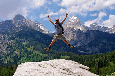
Jumping in front of Grand Teton on Taggart Lake Trail

Our next destination of the day was Victor, Idaho, which is where Christian, Drew's trail guide from his trip to Peru earlier this summer, had invited us to stay in his home for the night. Victor, Idaho has a population of under two-thousand people; it is one of those rural towns that we passed through many a time on our road trip and thought, "who lives in these places?" We turned off the main road onto a couple of unpaved roads and found the address with relative ease. The house is a very quaint wood home, appropriate for a dwelling near the mountains. From the time we walked in the door, Christian and his wife Sue made us feel at home. Their four and a half year old son, Nico, is quite the energetic young fellow and was almost instantly climbing all over Drew and I, asking us to play a game called "Dead Man" on the trampoline. The game involved one person closing his eyes, trying to tap another who was jumping and running around. It was interesting to say the least, but was very fun nonetheless. We also helped Christian put up a fence around their plethora of home grown vegetables and fruits in the gardens. Everything is organic or sustainable around here. Accordingly, the dinner did not disappoint. Sue made a delicious meal of chicken, a lettuce salad, a kale salad with goat cheese made from a neighbor's goat that Sue had milked, local Idaho potatoes, pesto, olive bread, and local beer. Along with Drew and I, Christian and Sue invited their neighbors over for dinner, and they gave us some great advice on where to stop in Idaho and Oregon. By now, the weather was turning sour and the winds had picked up dramatically. About an hour later, though, the dark clouds were passing and the sunset was showing through the clouds over the mountains. This scene encapsulated a beautiful day.


Sunset over the mountains in Victor, Idaho

Saturday, July 6, 2013

Day 13: Save the Best for Last

Yellowstone National Park

After a great night sleep (ignoring the puddles from a long, rainy night), Carl and I treated ourselves to solid breakfast at Ernie's Bakery in West Yellowstone. We had a long day ahead of us and needed plenty of energy. We enjoyed egg & cheese on bagels and and bought turkey sandwiches for the road. We planned to do a full-day hike and would need to stop for lunch along the way. With a few trails in mind, we left for the nearest ranger station to ask for suggestions.

While most rangers were surprisingly uninformed, the ranger working Madison Junction had hiked every single trail in our guidebook Day Hiking Yellowstone. She liked the two trails we had picked out but suggested a third: Avalanche Peak. When we entered the park our first day, the plan was to hike Avalanche Peak but we weren't prepared (emotionally, physiologically, etc). Carl & I were thrilled by her suggestion and decided to give it a shot. Armed with Counter Assault Bear Deterrent, we headed off to the Avalanche Peak trailhead.

Save the best for last, and we clearly did. The trail was scenic, less frequented, and at last, strenuous. In the two miles it took to reach the summit, Carl & I climbed 2,100 ft, caught amazing glimpses of wildlife, and played in the snow. There were few hikers on the trail so it felt as if we finally met the untamed Yellowstone. After taking our last few steps to the summit, we were met with roaring 40 mph winds and incredible views of the surrounding landscape. There was a small alcove where Carl & I could enjoy our lunches shielded from the wind.


Carl setting the table for lunch

After finishing our lunches, we decided to spend some time exploring the summit. A trail stretched along the ridge, interrupted every few hundred yards by small peaks. We left to climb the highest. As we worked our way along the narrow trail, the winds were terrifying. I held my hat tightly to my head as Carl & I worked our way slowly forward. Every step I thought where I could drop to the ground if the wind became too unmanageable. Eventually, we reached our destination and posed quickly to capture the incredible landscape.


Drew holds on dearly to his hat

Carl about to take flight

Satisfied, Carl & I began the descent from Avalanche Peak. We cheered on the few hikers we passed along the way and reached the parking in an hour. What was supposed to be a four hour hike, Carl & I finished in just over two. We decided to take the scenic route home. Instead of driving through the center of Yellowstone, we took the southern route through West Thumb. There we stopped to admire geysers and hot springs along the shore of Yellowstone Lake. Some geysers could even be spotted several yards off shore. As you might suspect, the West Thumb shore of Yellowstone Lake doesn't freeze during the winter.

After leaving the park, it started the rain so we had an uneventful night of playing cards and fast food. Quite an adventure today, and a great way to cap off our visit to Yellowstone National Park. Tomorrow we leave for Grand Teton.

Friday, July 5, 2013

Day 12: Time to Blow Off Some Steam

Yellowstone National Park

Waking up early in the tent is not very difficult (Drew may disagree) because everyone else is wide-awake cooking food around 7 a.m. But, this is not always a bad thing, because we want to get up as early as possible to get in as much as we can. Today we were able to leave the campground quicker than usual, as we are staying here for another two nights so we did not have to pack up the tent. Breakfast was a treat this morning at Running Bear Pancake House in West Yellowstone, Montana. Drew and I split some pancakes and an omelet, and we were well fueled to bask in the touristy glory that is Old Faithful. The line to get into the park was long, and we had to wait fifteen minutes to enter even though we already had our entrance ticket. The roads in the park were pretty clear, though, except for the occasional traffic for an Elk on the side of the road. It took us about an hour to get to Old Faithful, where the parking lot was already very full. Old Faithful is a huge geyser that shoots boiling water 100-180 feet into the air at an average of every 93 minutes. Drew and I arrived just in time to grab a seat in the amphitheater-like setting. There must have been at least 5000 people surrounding the most-famous geyser in the world. Nevertheless, the show did not disappoint. The water spurted for about 5 minutes before dwindling down to its usual low steaming.

Old Faithful erupting

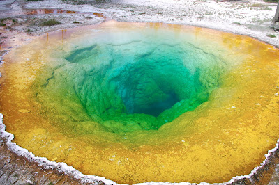
There are a bunch of trails, mostly on boardwalks, to see other hydrothermal features near Old Faithful. The entire landscape was alive with steaming cauldrons of super-heated water and gases. Besides the geysers, some of which shoot up to 250 feet in the air, there were some impressive hot springs. These colorful pools of water can be very dangerous. Apparently in 1970, a 9-year-old boy fell into one and died. Now they are very, very strict to stay on the walking paths. These paths allowed us to get pretty close, however, and we could see right down to the bottom of the pools. I thought the coolest springs were the Sapphire Pool, which was a gorgeous deep blue, and Morning Glory, which was a rainbow of colors. After a few hours of hustling to find parking spots and waiting in lines, we had enough post-July 4th tourism crowds and decided to head back to camp early. As we left the park, the skies opened up and it started pouring, which is why we are now sitting in the arcade room at the campground waiting for the rain to pass. Tonight we will grab dinner at a local restaurant and get to sleep early so we can get started tomorrow morning on a long hike.

Morning Glory hot spring

Drew and Carl in front of Sapphire Pool

Thursday, July 4, 2013

Day 11: Read it and... sheep?

Yellowstone National Park

Despite the initial fear of a grizzly attack, I slept quite well at Canyon Campground. The night was brisk, much preferred to the sauna grade heat we experienced in Badlands National Park. We got up early, ate a quick breakfast of Cliff bars, and headed off to hike Mount Washburn.

While the trail was listed as “strenuous” in our park guidebook, Carl and I found the hike easy and reached the summit in just over an hour. Atop Mount Washburn is one of Yellowstone’s three manned fire towers. As soon as the snow melts, a ranger is assigned to each of the towers and lives there for the duration of the summer. It might seem dull to watch for forest fire day and night but the view is spectacular.

Carl & Drew at the summit of Mt. Washburn

Just minutes after beginning the descent, we were stopped in our tracks. Off the trail was a family of Bighorn sheep. Four babes followed their mother up a slope far too treacherous for any hiker, and then posed for a photo shoot. It’s neat how park wildlife will get up close and personal. We put the cameras away and continued on.

Baby Bighorn climbing Mt. Washburn

However, right when we turned the corner, we were stopped in our tracks… again! And this time literally. Marching towards us was herd of about twenty Bighorn. Some Canadians we met on the hike up had the bright idea to climb up a nearby slope and let the herd pass. We joined them while most hikers backed up to the nearest junction. One by one the herd walked by but not before we snapped some awesome photos.

Carl and the Canadians avoiding the stampede 

Next, we grabbed lunch near Tower Falls and prepared ourselves for the afternoon activity: horseback riding. Carl was already a professional since he had ridden horses with his family in Montana. Still, it was new to me. We drove to the Canyon Corral early, signed our lives away, and waited for the tour to begin.

Somehow the wrangler completed his safety briefing in less than 30 seconds so Carl and I didn’t wait long to meet our horses. I was given Sneezy and Carl was given Dandy. Right from the get-go, I knew mine would be trouble. The wrangler had to drag Sneezy to me by his lead rope. The horse could tell I was a novice. We saddled up and were on our way.

Drew, Sneezy, Carl & Dandy at the Canyon Corral

The two wranglers led our group down a trail through the backcountry. You’ll find the main roads in Yellowstone can get pretty crowded. It was nice to see a more secluded area of the park. Aside our regular snack break (my horse kept trying to eat flowers), the ride went smoothly. For me and Carl, that is. Another guy nearly fell off his horse. To his defense, our saddles did slide around a lot. The horses were round and admittedly overfed.

We got back to the corral, said goodbye to Sneezy and Dandy, and left for West Yellowstone KOA. To our surprise, the campgrounds were pristine. We set up our tent and went downtown for dinner. After a solid dinner at Pete’s Rocky Mountain Pizza, we explored the town and set out to find a spot to watch fireworks. Happy Fourth of July! West Yellowstone put on quite a show.

Carl at the West Yellowstone KOA

Wednesday, July 3, 2013

Day 10: Bears and an Elephant Back

Yellowstone National Park

Today was our first day in Yellowstone National Park. We ate a simple breakfast at Cody Cowboy Village in Cody, WY, and then drove an hour and a half to the park entrance gate. The previous day, Drew and I researched cool hikes to do and one, the Avalanche Peak Trail, caught my eye. We asked the park ranger at the gate if he would recommend this hike, but the response we got was a stern "Do you have bear spray?" At first we thought he was joking, but he was completely serious, so we decided to pass on that trail, as we did not have the mace-like bear deterrent. Instead, we drove to the information station and asked a ranger which hikes he recommended. He was not the most knowledgeable ranger when it came to trails off the beaten path, but he did recommend the Elephant Back Trail. We also bought some bear spray just in case.

After a quick lunch at a park restaurant, we pulled on our hiking boots and headed over to the Elephant Back Trail. We quickly felt the effects of the high altitude as we were panting heavily during a 3/4-mile stretch, climbing 800 feet up in that short span. After this trek we were close to the top of the trail, where we had great views of Yellowstone Lake. We took in the scenery for a few minutes then headed back down the steep incline. We made it to the bottom, hopped back in the car, and drove north towards our campsite near Canyon Lodge. 


Yellowstone Lake from top of Elephant Back Trail

On this drive saw multiple Bison just walking leisurely in the street. The Bison are everywhere here. We saw even more at the Mud Volcano Area, which was our first glimpse of Yellowstone's 10,000 hydrothermal processes. Steam spewed from the ground and it smelled awful. Worse than just sulfur; it's hard to explain. Apparently we could not get enough of the stench, because after returning to the car, we stopped almost immediately at a place called the Sulfur Cauldron, which contained more hydrothermal features. This time there were mud pots, which are basically boiling globs of thick muddy glop. There was also a Bison basking in the warmth right on the edge, which we thought was funny.


Hydrothermal Mud Pots

 Drew in front of Bison next to Hydrothermal feature

While the sights were neat, the smell got the best of us, and we set up camp in Canyon Campground. We showered, got dinner at the cafeteria, which was not all that great, and then drove to see the Upper and Lower Falls of the Yellowstone River in the Grand Canyon of Yellowstone. The Lower falls were awesome. The water drops over 300 feet before splashing into the continuing river below. Sunset was approaching, which allowed us to get some really nice pictures. We stopped at a couple more viewpoints of the waterfall, and then called it an early night as we passed out in our tent around 10 p.m.


 Carl and Drew with Lower Falls behind

Tuesday, July 2, 2013

Day 9: Great Fun, Great Food

Rapid City, SD to Cody, WY

What was supposed to be an uneventful day of travel ended up being one of our best days. So much of what we did was simply unexpected. From our pitstops to meals, every moment was memorable. After sleeping in until 9 AM, we began the day with breakfast sandwiches at the local Black Hill Bagels. The egg and cheese sandwiches were awesome and we left for Devil's Tower.

Devil's Tower, our nation's first national monument, was formed more than 50 million years ago as magma rose through the Earth's crust. The monument is special because it is formed by hundreds of hexagonal columns, towering more than 1200 ft above the surrounding area. The easiest way to understand its structure is to imagine pencils tied together in a bundle. Even from miles away, the site was impressive. Devil's Tower emerges from a region comprised mainly of prairie. When we arrived at the base of the monument, we hiked the short 1.3 mile trail, admiring the incredible formation and rock climbers working their way its summit.

Drew at Devil's Tower

After leaving Devil's Tower, we started getting hungry and decided to grab a late lunch in Gillette, WY. Considering how many small towns we've driven through, it's been surprisingly difficult to find a solid local restaurant. Fortunately, we ran across The Coop, a small restaurant dedicated to rotisserie chicken and great service. Since we didn't have lunch until 3 PM, we had the places to ourselves and wow was the food good. Carl orded chicken tacos and I had the lettuce wraps. This dive served us our best meal so far in the 2,000 miles we've driven cross-country.

The Coop in Gillette, WY

We ate our fill and continued on to Cody, WY. The terrain quickly changed from prairie to mountain. We worked our way up snaking highways to an altitude of 9,000 ft and mountaintops covered with purple and yellow flowers, an area known as Bighorn National Forest. Eventually, we reached Shell Falls and decided to stop for a quick rest. The falls tumble an impressive 120 ft over granite into Shell Canyon. Nearby, Carl and I walked a short trail that explained the local fauna and hummingbirds that hovered overhead. One plant, called Yellow Rabbitbrush, was once used to treat toothaches by inserted mashed leaves into cavities.

Carl admiring Shell Falls in Bighorn National Forest

Finally, we arrived in Cody, a fun gateway city into Yellowstone National Park. We're staying at the Cody Cowboy Village, a relatively new hotel made up of 20 or so log cabins. It's really nice. The owner came out to talk to us and recommended we have dinner at the local Rib & Chop House downtown. Today was easily our best day of eating. I somehow managed to scarf down a 1 lb buffalo steak while Carl enjoyed his dainty filet mignon. Dessert was a gigantic "ice cream sandwich" with vanilla ice cream sandwich sandwiched between 2 brownies. Now, we're back at the hotel getting ready for our first day in Yellowstone National Park. Excited for the days to come...

Monday, July 1, 2013

Day 8: Mount Rushmore, Crazy Horse, and Wind Cave

Black Hills of South Dakota

Waking up this morning at the campground was not that difficult with all the children crying and screaming at 6:00 a.m. We managed to stay asleep until about 8:30 a.m., however, and we packed up the tent and headed over to all you can eat pancakes for $2.50. After our quick but very filling breakfast, we drove to Mt. Rushmore to feel some real American patriotism. I was amazed at the precisely sculpted appearance of the heads of George Washington, Thomas Jefferson, Theodore Roosevelt, and Abraham Lincoln. The faces were situated on what seemed like every other mountain in Black Hills National Forest and Custer State Park. Each face was about sixty feet high, with their noses being about twenty feet high. Before today, I never understood how this monument was sculpted, and what I learned was that ninety percent of the rock was blasted away with dynamite. The dynamite was drilled in very exact locations to remove tons and tons of limestone. The result was an awesome American marvel.

Mount Rushmore

Not to be outdone, the American Indians who called the Black Hills home for centuries wanted a monument of their own to show the "White Man" that they also had heroes. They called upon Korczak Ziolkowski to sculpt Crazy Horse, a legendary Native American war hero, into a mountain. Started fifty years ago, the monument is not even close to completion. This makes sense, though, considering its immense size; all four of the presidential heads on Mount Rushmore could fit inside Crazy Horse's head. The connection between the sculptor Korczak and the sculpture made the monument more meaningful for me. After Korczak died, his wife and seven of his ten children continue to work on and for the monument and museums at the base. They deny any federal funding because they believe that people should want to come and pay to see the progress or donate to help it along. It is and will always be a sculpture for the people.

Crazy Horse Memorial sculpted in wood

Crazy Horse Memorial at current status

After seeing the Crazy Horse Memorial, we drove to Wind Cave National Park. Wind Cave has two main components, a large prairie and forest above, and a huge cave below. The prairie above is home to bison, which we passed on the way into the park, and many other prairie animals. While the pastures above are nice, what's amazing is the labyrinth of cave below. In the 1970s, there were about thirty two miles of cave mapped, and now there are one hundred and forty miles mapped. Geologists estimate that there could still be another ninety five percent of cave that is yet to be discovered. Wind Cave is already one of the largest caves in the world, with thirty stories worth of cave. Most caves that I've seen have the typical stalagmite and stalactite formations, but Wind Cave has some rare features consisting of "cave popcorn" and "boxwork," which is composed of thin calcite fins resembling a honeycomb. The cave popcorn are just small knobby growths from the sides of the cave where the water seeps through the limestone. The physical characteristics of the cave along with the history of its discovery made this one of the highlights of the road trip so far. 

Drew in Wind Cave National Park

Closeup of "Boxwork"

Closeup of "Cave Popcorn"

By now it was evening, so we drove back to Hill City via the Needles Highway where we almost got run off the very narrow road. We drove through some awesome rock formations and finally reached Hill City unscathed. Famished because we skipped lunch, we grabbed a quick bite to eat and are now sitting in our hotel in Rapid City, SD looking forward to our six-hour drive tomorrow.

Driving through narrow rock formations on Needles Highway

Sunday, June 30, 2013

Day 7: Mountains (of Ice Cream)

Badlands National Park to Hill City, SD

We woke up to the sunrise and were on our way. After a full day in the Badlands yesterday, we decided to head over to Custer State Park and check out a trail recommended by the Park Ranger. Harney Peak was just about 2 hours from Badlands National Park so we hopped in the car and started up Harry Potter. I forgot how far we've driven already -- finished the Chamber of Secrets halfway through the ride.

Eventually we reached Hill City and booked a campsite at the nearby KOA. The Badlands campground might have had 80 campsites but this place has hundreds. According to Carl B, KOA is a chain of campgrounds with more than 500 locations across the USA. We drove through a maze of fire pits, RVs and tents until we settled on a site close to the creek. Currently listening to a delightful melody of toads chirping. We left to begin our ascent.

The trip to Custer State Park was an adventure in itself. We drove through a stretch of road known as Needle Highway. This curvy road would have made most men sick but Carl and I were brave. Through rock tunnel and sharp turns, we arrived at Sylvan Lake, the starting point for our hike.

 Carl B relaxing by Sylvan Lake

The 6 mile loop took us up 1,500 ft to an altitude of 7,242 ft. The view was incredible. Harney Peak is the highest peak between the Rockies and Swiss Alps. Perched on top was stone tower that on a clear day has views of 3 states: South Dakota, Wyoming and Nebraska. Around this tower were smaller peaks asking to be climbed. We explored for an hour, took photos, and began the descent. While the climb up took more than 2 hours, it took a little over an hour to make our way back down.

Carl & Drew at the summit of Harney Peak

After hiking, we went back to the KOA for a quick shower and left to grab dinner in Hill City. Dinner was pretty uneventful but on the way back to our car, we passed an ice cream parlor and couldn't resist. Carl ordered a combo of Rocky Road and Moose Tracks and I had Cookies & Cream with Mint Chocolate Chip. The waffle cones they served us must have held 1 pint of ice cream each. I still don't know how Carl finished his.

Now we're back at the campsite getting ready for our second night in a tent. I'm looking forward to another great night sleep.

Saturday, June 29, 2013

Day 6: Prairie Dogs and Bison Burgers

Sioux Falls, SD to Badlands National Park, SD


Our day started off by eating a small breakfast in the hotel consisting of some cereal and Thomas’ Bagels. Not the most filling or nutritious of breakfasts, but it was enough to hold us off for the four and a half hour drive ahead to Badlands National Park in South Dakota. The entire drive was on I-90 W, which took us straight across the vastest farmland and prairie that I had ever seen. It was almost surreal. There was so much green, and it was all so uniform with what Drew and I suspect were wheat farms. Behind some of this green sea were hundreds of wind turbines, which seemed appropriate considering the consistent 25 mph wind.

After driving for a while, we started seeing rocky outcrops on the horizon, which ended up being the tips of the Badlands. We got off the exit, entered through the toll-like pay station for the park fee, and drove on curvy roads through the massive stone hills to the Ben Reifel Visitor Center where we mapped out our day and had some lunch. Our campground was down the street so Drew and I checked it out before proceeding to our hikes for the day. After parking the car at the trailhead, we climbed a small mountain for about a quarter mile. This was pretty much the only “hiking” we did today. There was a great view of the prairie from the top of that difficult “Saddle Pass” trail. The rest of the “hike” was more of a walk through the fields of the Badlands. The views were good, however, and to me the tabletop-like stone structures were the most interesting forms. It was almost as if the ground had just collapsed around them, creating ninety-degree angled edges to the rest of the ground about ten feet below. Drew and I discussed being inspired by these forms to build a golf course. Each hole would consist of island fairways and greens surrounded by fescue, sand, and rocks off the sides. The rock that makes up the Badlands was surprisingly soft and brittle. It seemed like the dirt and clay could easily be carved by wind and rain. While we did feel the high winds, I am glad we did not feel the rain. That would have been one muddy experience.


 Drew standing atop a Badlands mound

The Badlands and prairie

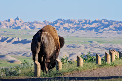
After walking for about three hours, we got back in the car and decided to drive the Badlands Loop, which is a sixty-mile loop through and around the park. We were just hoping to see more of the sharp spires and flat prairie, but we were in for quite a treat. At any sight of wildlife, the cars on the road stop, admire, and take photos. The first stop was for thousands of prairie dogs. We saw one, and then another, and then we looked around and saw the countless mounds of dirt and more prairie dogs. They seemed to be calling to each other to warn of our approaching, but we still got some great pictures. The next stop we made was for bighorn sheep lambs. There were about ten that crossed the road along with six baby sheep lambs. We then turned onto an unpaved road because someone watching the goats with us said that there had been bison up that road earlier in the day. Before we knew it we saw four bison about three hundred yards away from us in the field. They were walking towards the road ahead so we drove there and waited for them. We ended up being just a few feet away. Those things are MASSIVE (and they slobber and groan a lot.) The bison used short wooden poles in the ground to scratch their heads and bellies. While it was funny, we had to be on our toes incase the beasts became less docile and ran. Luckily they stayed calm and we drove away with an amazing memory.


Prairie Dog surveying its surrounding

Mother Bighorn Sheep with daughter 

Close up of Bison scratching itself on the wooden poles 

Bison looking off into Badlands wilderness


After going on the unpaved road for so long, the pavement was a sight for sore eyes. We drove to Wall, SD, where we finally experienced Wall Drug Store, which had been advertised at least once a mile for the past four hundred miles, since Iowa. The store is a huge chachka shop with a restaurant. We ate in the restaurant, where the food was just okay, and then drove back to camp. By this point the sun had begun to set, so we had to set up our tent quickly. As darkness fell, one of the park rangers gave a presentation about myths and creatures of the Badlands. We learned that the name “Badlands” has two possible origins. Either the native Lakota Indians called them bad land because they were impossible to farm, or the early American settlers called them bad because the difficulty in crossing them to go East-West. While this was interesting, the presentation was focused towards children, so Drew and I left early. We went back to our tent, waiting for complete darkness and then observed the amazing nature that is the universe; there were so many stars, and the Milky Way was as smooth as ever. It was a sparkling end to our sixth day on the road.